


")
")
")

")
")

Mikä on Traficom M71-vaatimus?
Traficom määräyksen tarkoituksena on varmistaa verkkoinfrastruktuurin yhteisrakentamisesta ja -käytöstä annetun lain (276/2016) tarkoittamaan keskitettyyn tietopisteeseen toimitettavien tietojen riittävä tarkkuustaso ja yhteentoimivuus. Määräyksen tarkoituksena on edistää verkkojen yhteisrakentamista ja -käyttöä sekä vähentää maarakennustöistä verkkoinfrastruktuurille aiheutuvia vaurioita.
Traficomin määräys M71 astui voimaan 1.6.2020. Sitä sovelletaan viestintä-, energia-, vesihuolto- ja liikenneverkkojen tietojen toimittamiseen. Määräys vaatii 1.1.2021 lähtien rakennetuista uudesta verkkoinfrastruktuureista ja aktiivisista verkon osista ilmoituksen verkon sijaintitiedoista x- ja y-koordinaatein taajama-alueella ± 10 cm tarkkuudella, sen ulkopuolella ± 50 cm tarkkuudella, sekä z-koordinaatin tai sijainnin syvyystiedon ± 10 cm tarkkuudella. Verkonomistajien tarkkuusvaatimukset ovat usein tarkempia kuin määräyksen edellyttämä tarkkuus. Tietoa tulee toimittaa vektoriaineistona Sijaintitietopalveluun 1.4.2022 alkaen.
Carunan paikannus-haaste
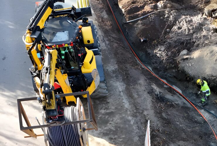
Lähdimme aikanaan mukaan Suomen suurimman verkonomistajan Carunan innovaatiohaasteeseen (2019) kehittämään Traficomin M71-määräyksen täyttävää ratkaisua. Noin puolen vuoden aikana syntyi toimiva konsepti FIELDSIGHT GEO -tuotteelle, joka käytännössä ratkaisi Carunan asettaman haasteen ongelmat. Innovaatiokilpailun voiton jälkeen tuotetta ja palvelua lähdettiin kehittämään tiiviisti yhteistyössä verkonomistajien ja urakoitsijoiden kanssa helposti käytettäväksi kokonaisratkaisuksi, joka sopii eri verkonrakennuksen osapuolien käyttötarkoituksiin. Nyt vuonna 2022 tuotteesta ja ratkaisusta on olemassa kolmas sukupolvi vaativampaankin käyttöön, joka tehostaa kaapelointiprosesseja merkittävästi.
")
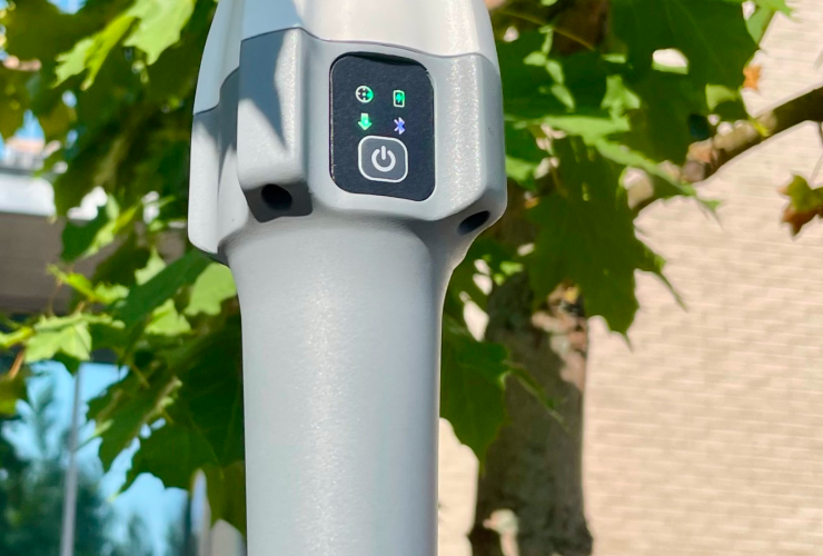
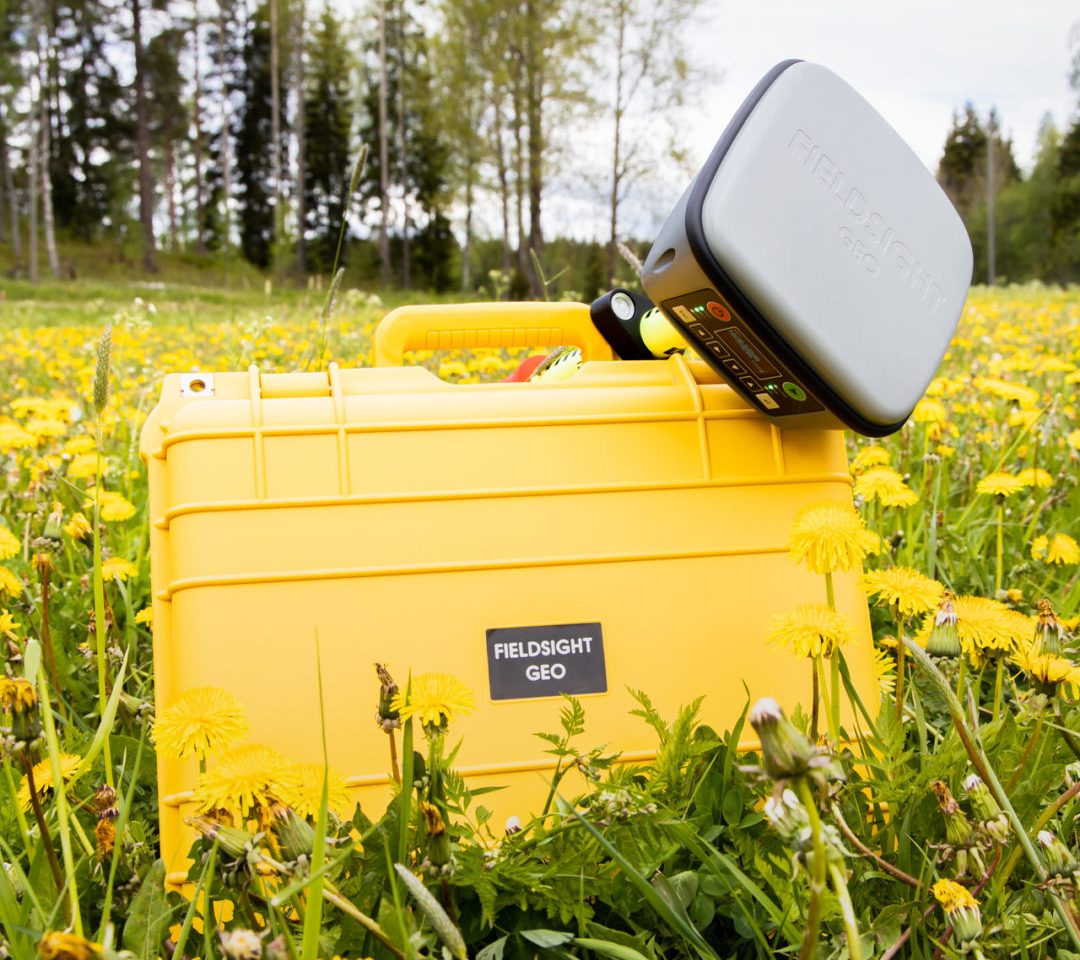
Fieldsight GEO
FIELDSIGHT GEO -ratkaisumme vastaa mm. Traficomin määräyksen tuomiin haasteisiin ylittämällä reilusti sijaintitiedon tarkkuusvaatimuksen raportoimalla sijaintitietoa aina jopa cm-tarkkuuteen asti. GEO-laite lähettää määräyksen vaatimat tiedot (sisältäen mm. paikkatiedon x,y,z, kaapelin laskusyvyyden ja suojausluokan) pilvipalveluun, josta tieto välittyy selainpohjaiseen reaaliaikaseurantakäyttöliittymään. Tämän lisäksi tieto konvertoituu automaattisesti oikeassa muodossa verkonomistajan GEO-tietoformaattiin päätyen suoraan esimerkiksi Trimble NIS -järjestelmään. FIELDSIGHT GEO -tuote auttaa maarakentajaa tekemään parempaa laatua heti työmaalla valvoen mittaustarkkuutta, mittausväliä ja muita laatuparametreja dokumentoiden tehdyn työn digitaalisesti. Näin vältytään jo työmaalla mahdollisilta kalliilta rakennusvirheiltä. Olemassa oleva infra nähdään kartalla ja vältytään siihen liittyviltä vaaroilta. Tehty ja varmistettu laadukas työ on heti dokumentoitu ja laskutettavissa. Näin ollen myös liiketoimintariskit ovat maarakentajalle ja urakoitsijalle reaaliaikalaadunvarmistuksen myötä minimaaliset. Paperipiirustuksiin tehtävät punakynämerkinnät esim. suojausluokkien aloituksesta ja loppumisista voidaan unohtaa työn dokumentoituessa digitaalisesti Fieldsight-ratkaisun avulla.
")
Fieldsight GEO:n hyödyt tiivistetysti
- Traficom M71-määryksen tietojen yhteensopivuus
- Laadunvarmistus työn aikana vähentää merkittävästi rakennusvirheitä
- Projektinseuranta yksinkertaistuu
- Laadukas työ laskutettavissa heti päivän jälkeen, jolloin pääurakoitsijan ja maarakentajan liiketoimintariski on minimoitu
- GEO-tiedon automaattinen käsittely ja konversio verkonomistajan tietoformaattiin säästää merkittävästi resurssoinnissa
- Maanmittausresurssi voi keskittyä oleelliseen eli reaaliaikaisen tiedon tarkisteluun ja paikkatiedon viimeistelyyn
- Yksinkertainen, edullinen työkalu kenttätyön digitaliseen dokumentointiin
- Kaikki vaadittu kenttädokumentaatio sisältäen 360° kuvat ja ojanäkymä yhdellä napinpainalluksella
- Ratkaisu edistää vihreää siirtymistä: reaaliaikatiedon ja kuvien avulla matkustus työmaalle vähenee merkittävästi ja näin CO2-päästöt pienenee
Kiinnostuitko?
Laitetaan verkonrakennuksen digitalisointi ketterästi käyntiin Fieldsight GEO -ratkaisun avulla. Jätä yhteystietosi alle, niin otamme sinuun yhteyttä ja esittelemme ratkaisua sekä sen tuomia etuja tarkemmin: